Humanitarian crisis in Ukraine: support for the MSF GIS Centre

MSF has been active in the country since the beginning of the conflict and in all of Ukraine’s neighboring countries. The movement is actively supporting the local population, as well as internally displaced people and refugees, through several initiatives: i) facilitating access to drinking water and sanitation (installation of generators, solar pumps, etc.) to ensure the proper functioning of health facilities, ii) providing essential items (such as baby kits, COVID kits, etc.), iii) offering psychological support, iv) providing medical consultations via mobile clinics, as well as v) performing various logistical activities (such as transporting patients, particularly by train – report in French).
All current operations have expressed significant needs in terms of spatial data and mapping. First of all, it is important to locate and qualify the activities being carried out, in order to cross-reference them with the different vulnerability factors that may represent a risk for the teams involved as well as for the local population (chemical, nuclear or bacteriological hazard, monitoring of bombings and their intensity, shelter locations, etc.). These needs can be translated into static or dynamic form (PDF maps or geoapps) and help to and/or allow to orient the operational strategy of MSF coordination teams. In the background, these products generate important needs in terms of spatial data management. Cleaning, homogenizing, transforming, structuring, updating and automating these processes allow, among other things, to ensure that all the support provided by these geographic information systems is as efficient and up-to-date as possible, based on the information available.
After a first 5-week mission between Poland and Ukraine, led by a GIS & Database Specialist, a second 4-week deployment was carried out by a Mapping & GIS Specialist in Ukraine. Here is their feedback.
1- What was the objective of the first mission and in what context did it take place?
[GIS & Database Specialist]
This first mission follows the deployment of a GIS Advisor from the Geneva OC in the first weeks of the conflict to diagnose what were the exact mapping and spatial data needs of the MSF teams deployed in the field. Such a diagnosis confirmed the need for the in-country deployment of a GIS team, fully dedicated to the support of MSF operations initiated since the beginning of the conflict.
To this end, this first mission implied meeting with the teams of the different OCs who had been deployed to identify their needs and formalize them into the most appropriate form. This was the role given to my counterpart, a cartographer sent to cover, during the mission, most of the existing projects in the country. In most cases, this led to the real-time development of web applications based on the feedback he was getting during his visits, which I managed from the transit base of the Geneva section in Poland.
We were given an intersectional mandate, which allowed us to respond to the requests and demands of all the OCs present on site. What was also special about this mission was that we were operating in a critical emergency context (with strict security protocols in place), which explains the dual location between Poland and Ukraine and also the relatively short duration of the deployments in this type of context.
2- What were the main advances brought by this mission to MSF’s operational teams in the field?

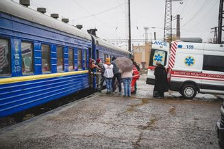
Arrivée du train médicalisé à Lviv.
1er avril 2022. Ukraine. © MSF
Exemple d’actions menées par MSF en Ukraine.
Plus d’informations dans cet article.
[GIS & Database Specialist]
This first mission allowed us to centralize and structure the specific data related to the war ongoing in Ukraine, in order to make them visible and accessible to the operational teams through static or dynamic maps (geoapps). These GIS products allow, in turn, to facilitate decision-making in the field for MSF coordinations in the implementation of specific projects or activities, and beyond this, to guide overall strategies of action and of deployment regardless of the section. Because of our presence in the field, it was also possible for us to polish the work done based on direct feedback in order to better respond to their requests and support their activities.
For example, we created an application in which it is possible to follow over time – since the beginning of the war – the location of the shelling/blast/explosion recorded everywhere in Ukraine, as best as possible based on the available data. These first locations were also cross-referenced – in another geoapp – with sensitive locations that could represent potential targets, allowing coordination teams to make informed decisions in the implementation of their activities. Another web application was designed to support one of MSF’s 5 OCs in Dnipro and Zaporijia (south-east of Ukraine), by referencing the location of reception centers for people who had had to flee their homes (or, as the official term states “internally displaced people”) as well as health facilities in order to support the work of mobile medical teams and to guide people needing it towards health centers.
In the end, we produced 5 static maps on ArcGIS Pro and 4 online applications on Portal within 5 weeks, while developing, in parallel, sound data management and processing workflows.
3- How did the first mission inform the process and objectives of the second deployment? Was this one different from the first, and if so, how?
[Mapping & GIS Specialist]
The second mission, which took place from mid-May to mid-June, was truly a continuation of the first deployment, with the exception that only the mapping specialist was replaced, by myself (deployment in Ukraine), while the data management specialist returned to France to support the OCs remotely.
As for the rest, I had to keep maintaining the tools already in place, develop new ones according to the needs regularly expressed by the field teams as well as train them to use them (for example, by teaching them how to organize an Excel file correctly, in order to keep it up to date, and by doing so make it possible to keep feeding an online application with new data – which is being added thanks to HQ’s support via an ETL tool).
Similarly to the first mission, I also spent a lot of time communicating with project teams to ensure that they were kept informed of the GIS tools made available to them. Although all the products are centralized on the GeoMSF platform, which is accessible from headquarters and the field, it was still necessary to communicate actively in person, via emails, etc. This is a crucial element, especially when taking into account the high turnover of teams in emergency contexts.
4- What are the main achievements of this second mission?
[Spécialiste SIG en cartographie]
[Mapping & GIS Specialist]
In addition to what I mentioned earlier, I also want to highlight the documentation work that was done, and the support provided for the recruitment of a national GIS specialist – which had been recommended at the end of the first mission – in order to stabilize the handling of GIS needs on site.
I want to reaffirm that this is a very useful tool that we use in many ways. Thank you for all the work done.
– Feedback from a Ukraine-based head of mission about an application developed during the first mission.
5- Looking back, what did you find most complicated to manage? How do you think the work done during these two missions still supports MSF teams in the field?
[Both]
Due to the crisis situation, gaining access to project teams was sometimes challenging, and they also had limited availability – something we had to manage to get the job done. Projects are also very scattered, which means complicated logistics (long car journeys, etc.). For these reasons, we believe it would be best to revert back to a “GIS duo”, by combining the data component with the mapping one more closely. It is indeed quite difficult for a single person to manage everything while responding to the needs of all field teams.
We did not encounter any major connectivity issues, despite the situation. However, we realized the importance of constant communication in crisis situations, again due to the high turnover in teams. Moreover, it was important to adapt our approach according to our interlocutors, who had quite heterogeneous levels of understanding and knowledge in the use of GIS tools.
On a more personal note, and like any mission in a crisis context, it was not always easy to manage being away and the relationship with our loved ones back in France, and the accumulated fatigue quite typical in a field mission.
As for the rest, although we acknowledge how dire the situation is in Ukraine – something we absolutely cannot ignore – for us, these two missions were also in fact a formative experience. Getting to meet and work with field teams greatly facilitates communication and makes our support ever more concrete. The first mission allowed us to really establish the foundations of later work, also starting a cycle of support and communication across OCs about GIS needs and products to prioritize – particularly in the form of dynamic maps accessible to all sections and more sustainable in the long run. The second mission consolidated this initial phase of work, also allowing us to update GIS tools to reflect the ever-changing needs stemming from the highly volatile context of conflict zones.
