EPIMAP
About
Description
Epidemics are an important context of intervention and support to MSF activities. Data related to epidemics have a very important spatial component to identify areas of potential contamination or lack of follow-up. The clear presentation of the indicators associated with an epidemic and the spatialization of the information collected enable MSF to make more informed decisions.
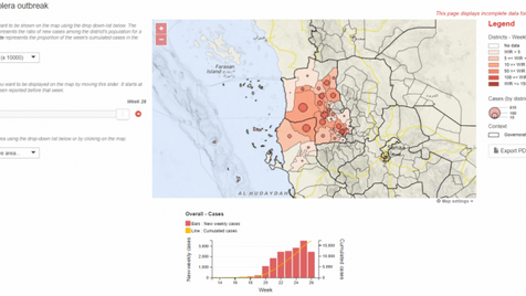
In the context of a cholera epidemic in Yemen in 2017, CartONG developed the first EpiMap for MSF’s GIS Centre teams.

Based on a simple Javascript architecture, the EpiMap can be viewed on any web browser, stored locally on a computer, or hosted on an online platform. Its data input parameters are simple and robust, with tabular statistical values linked to geospatial data. Formatted visualizations can be exported as PDFs and printed for use in the field. In the event of a complete communication failure, the tool retains all of its original analysis functions, as all data layers are stored locally and the only function that relies on connectivity is a live OpenStreetMap background.
In Yemen in 2017, the initial version of the map was used to strengthen the overview of the outbreak and better plan response activities at national level. During the 2018 Ebola response in the Bikoro region (DRC), field teams used the tool to improve their understanding of the chronological transmission of the virus in remote areas of the Equator province. The flexible design of the tool allowed it to be quickly adapted to its context, displaying cases at a village level rather than at a regional level, and proved the potential of its full offline capacity during operations in remote areas. Since these first examples, EpiMap is implemented every time an outbreak occurs and the needs are sent by the team to have an easy follow-up.
The EpiMap, its original code, and practice datasets are made available on GitHub for educational purposes.