Mapping for Easy Health access
About
Description
The Global Healthsites Mapping Project is an initiative to create an online map of every health facility in the world and make the details of each location easily accessible. It is an open development initiative, where health facility data is freely available to everyone and everyone can contribute by authenticating through a social media account, and easily adding, updating or sharing data on Healthsites.io. The ultimate goal of the project is to create a data life cycle with OpenStreetMap (OSM) – where imported OSM data is validated and improved by users and humanitarian organizations and then saved back to OSM (see model here).
Since 2016, the Global Healthsite Mapping Project has grown into a partnership with the International Committee of the Red Cross (ICRC), the International Hospital Federation (IHF), Médecins Sans Frontières GIS Unit (MSF Switzerland), the Health Care in Danger Project and the Humanitarian OpenStreetMap Team.
When CartONG joined the partnership in 2017, the initial focus of our contribution was on the evolution of the baseline health facility attributes. Initially developed by the International Hospital Federation this baseline of health facility attributes would be aligned with OpenStreetmap and lay the foundation for the data life cycle.
In 2019, in collaboration with Geomatica (a Senegalese company specialized in GIS) and the OpenStreetMap Senegal community, CartONG organized a 2-week mission in Senegal with the full consortium. During the first week, we organized a comprehensive data collection campaign in the département de Saint-Louis, in the north of the country. After getting approval from the local head of the Ministry of Health (MoH), we trained a group of 10 young enumerators, members of the local OSM community or staff at Geomatica, during a day. We used the new Healthsites.io ODK form accessible via the platform, to write the data on OpenStreetMap (using Gather). The enumerators had the rest of the week to cover the full département.
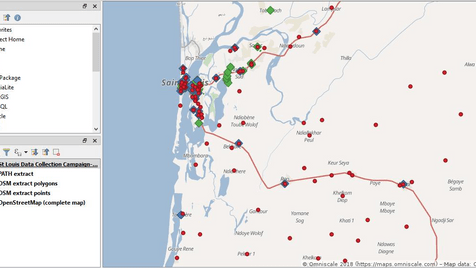
In total, 104 health facilities were surveyed, including detailed attributes on opening hours, number of staff, number of beds, accessibility, power and water access conditions, etc. This dataset was much more exhaustive than pre-existing data in particular in rural areas, as shown in the screenshot below, which compares data collected in our campaign (in red), existing data in the dataset gathered by PATH over the last months (in blue) and existing data in OSM (in green). The second week of the mission was then dedicated to presenting and promoting our approach to local stakeholders.

CartONG’s technical support has demonstrated the possibility to scale up the use of the Healthsites.io platform and tools, and fostered discussions among local actors on data collaboration. Healthistes.io and OSM Senegal continued their efforts to improve data sharing, with other departments mapped and additional advocacy efforts.

