2 GIS training missions in the field to support the MSF GIS Centre
2 countries, 100 hours of training, 30+ participants
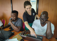
Pascaline, géomaticienne à CartONG formant le personnel
de MSF à Kinshasa, mai 2023
At the end of April, a member of our team traveled to Kinshasa to contribute to a week’s training for MSF’s GIS specialists, some of whom were based at the headquarters. This first cycle was repeated at the beginning of June with a second week of training, this time in Kampala: the outcome of the mobilization of our entire GIS team in the production of this training over the last few months!
These courses cover static and dynamic mapping tools – in particular ArcGIS Online and ArcGIS Pro – and database management. Delivered in both English and French, they complement the day-to-day support we provide to field teams in map production.
These training cycles, with participants coming from different operational contexts, have not only enabled us to harmonize the practices of different fields, through the use of templates, but also to understand their needs in order to adapt to operational realities the support that the MSF GIS Centre, and consequently CartONG, provides today to local missions.
“In the framework of my GIS advising role, getting a complete overview and practical knowledge of technical components is essential, not only to better communicate with the different substreams but also to be myself a producer of GIS products once needed… during needs assessment visits or complex emergencies for instance. This training gave me all what I needed in this regard.” – MSF GIS Advisor about the training in Kampala
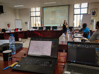
Atelier pratique pendant la formation à Kampala, juin 2023
Empowering field teams
While these two training cycles were intended to strengthen the capacities of MSF’s GIS specialists, our team continually trains and introduces its teams to mapping and GIS. Among others, this was the case during a week of training in Brussels in May, and also in Amman in January. Since the beginning of the year, CartONG has trained over a hundred people in GIS as part of its partnership with MSF.
“These training courses play a key role in enhancing the skills of humanitarian actors and their use of GIS to deliver a targeted and effective response. This training has enabled specialists already on mission to ensure that GIS plays a key role in the response and in MSF’s activities.” explains Pascaline, CartONG’s GIS Officer who has given several training courses in support of Doctors Without Borders. By making teams autonomous in the use of GIS and the publication of maps, these training courses help them to respond more rapidly and accurately in emergency situations.
“The training materials are concrete and adapted to the reality of the field. I learned a lot by handling the tools and techniques applied during the practical workshops. The training is in line with our needs and provides us with useful and concrete tools.” – MSF Flying GIS Specialist for emergencies
Coming soon
Over the past few years, our support and expertise in terms of training content creation and facilitation has grown, both in support of MSF and other actors in the sector. This development reflects the ever-increasing needs and demands of teams in the field in terms of mapping, GIS and, more broadly, data management.
As part of its partnership with MSF, CartONG will shortly be sending a member of its team to Kenya for a 3-week mission to support the onboarding of a new GIS Specialist.